Laboratory study of filtration regimes in the body of earth dams
УДК 624.171+624.139
Abstract
The study aims to assess the seepage regime of the earth dam of the Qamashi Reservoir using a 1:100-scale physical model and field observations at section PC16+30. The experiment was conducted in a transparent hydraulic flume using a model constructed from loam soil. The upstream water level was maintained at a constant level corresponding to the elevation of 487.68 m in the prototype. Water penetration into the dam body, the wetting front, and the development of the phreatic surface were observed every 5 minutes. During the experiment, water temperature (19.2 °C) as a control parameter, water density, soil bulk density, settlement of the model crest, and the average hydraulic gradient were determined. Seepage water reached the downstream toe 41 hours after the beginning of the experiment. The water density was 999.6 kg/m³, soil density was 1650 kg/m³, model crest settlement was 2 mm, and the average hydraulic gradient was 0.12. The phreatic surface formed in the laboratory was close in overall configuration to the field observations. Under the adopted laboratory conditions, the seepage process developed gradually and the average hydraulic gradient did not exceed the specified limiting values. The developed model can be used for a qualitative assessment of the seepage condition of the Qamashi dam; however, the results should be interpreted within the adopted model conditions and structural simplifications.
Аннотация
Целью исследования является оценка фильтрационного режима земляной плотины Камашинского водохранилища с использованием физической модели в масштабе 1:100 и результатов натурных наблюдений на поперечном сечении ПК16+30. Эксперимент проводился в прозрачном гидравлическом лотке с применением модели, изготовленной из суглинистого грунта. Уровень воды в верхнем бьефе поддерживался постоянным и соответствовал отметке 487,68 м в натурных условиях. Проникновение воды в тело плотины, продвижение фронта увлажнения и формирование депрессионной поверхности фиксировались каждые 5 минут. В ходе эксперимента были определены температура воды (19,2 °C) как контрольный параметр, её плотность, объёмная плотность грунта, величина осадки гребня модели, а также средний гидравлический градиент. Фильтрационная вода достигла подошвы низового откоса через 41 час после начала эксперимента. Плотность воды составила 999,6 кг/м³, плотность грунта — 1650 кг/м³, осадка гребня модели — 2 мм, а средний гидравлический градиент — 0,12. Депрессионная поверхность, сформировавшаяся в лабораторных условиях, по своей общей конфигурации была близка к результатам натурных наблюдений. При принятых лабораторных условиях фильтрационный процесс развивался постепенно, а средний гидравлический градиент не превышал установленных предельных значений. Разработанная модель может быть использована для качественной оценки фильтрационного состояния плотины Камашинского водохранилища, однако полученные результаты следует интерпретировать с учётом принятых условий моделирования и допущенных конструктивных упрощений.
Keywords: Qamashi Reservoir; earth dam; seepage regime; physical modeling; phreatic surface; hydraulic gradient; field observations; crest settlement.
Ключевые слова: Камашинское водохранилище; земляная плотина; фильтрационный режим; физическое моделирование; депрессионная поверхность; гидравлический градиент; натурные наблюдения; осадка гребня плотины.
Introduction
Earth dams are among the most widespread structures in hydraulic engineering, and their reliable and safe operation is important for the efficient use of water resources, stable water supply to irrigated lands, and prevention of emergency hydrodynamic events. The technical condition of such structures is determined not only by the strength of the dam body but also by the characteristics of seepage flow through the dam body and its foundation. Uncontrolled seepage can cause migration of soil particles, internal erosion, suffusion, increased pore-water pressure, wetting of the downstream slope, and local deformations [1].
The difference between water levels in the upstream and downstream pools generates seepage flow through the soil pores. As water moves through the dam body, a free seepage surface—the phreatic surface—develops. Its position and the point where it intersects the downstream slope affect the degree of saturation of the dam body, pore-water pressure, seepage discharge, and slope stability. Therefore, determining the position of the phreatic surface is an important part of assessing the technical condition of a dam.
Analytical calculations, numerical modeling, laboratory experiments, and field observations are used to investigate seepage processes in earth dams. Although analytical methods describe the general laws of seepage, they are limited in fully accounting for soil heterogeneity, differences in compaction, and actual boundary conditions. Numerical models can provide high accuracy, but their reliability should be verified against laboratory or field data. Al-Janabi et al. demonstrated close agreement among results obtained using a physical model, the Casagrande method, and the SEEP/W software [2].
The hydraulic conductivity of soils within a dam directly affects the phreatic surface, seepage discharge, and distribution of hydraulic gradients. Mostafa and Zhenzhong found that changes in hydraulic conductivity in dams composed of zones with different seepage coefficients can reduce the overall seepage discharge while increasing pore-water pressure and local hydraulic gradients in some sections [3]. This indicates that seepage safety assessment should consider not only the total seepage discharge but also the phreatic surface and local hydraulic gradients.
Changes in the reservoir level over time also affect the seepage regime. When the water level rises, the saturated portion of the dam body expands and the phreatic surface shifts upward. When the level falls, the seepage field transitions to a new state with a certain delay. Liu et al. showed that the rate of water-level change and the soil water-retention characteristics can cause hysteresis in pore-water pressure and downstream slope stability [4].
Temperature should be recorded as a control parameter in laboratory seepage studies because it affects the dynamic viscosity of water and the hydraulic conductivity of soil. At the same time, temperature monitoring can be used as a diagnostic tool for identifying seepage paths and hidden leakage zones in earth dams. Fabbian et al. demonstrated the possibility of identifying seepage zones through temperature monitoring [5], while Radzicki and Stoliński applied a multi-point thermal-active system under field conditions [6].
Experiments conducted on loess and sand soils have shown that temperature changes can significantly affect hydraulic conductivity. Yang et al. found that the saturated hydraulic conductivity of loess increased with increasing temperature over the range of 7–44 °C [7]. Studies by He, Jiang, and Wang also reported significant changes in the hydraulic conductivity of sand under the influence of temperature [8]. These findings confirm the need to account for water temperature in laboratory experiments.
Studies assessing the seepage condition of earth dams that have been in long-term operation in Uzbekistan have substantiated the need for regular monitoring of piezometric levels, drainage systems, seepage flow, and local deformations [10]. Studies of the Qamashi Reservoir have also considered the possible effects of seasonal temperature changes on water viscosity, the soil seepage coefficient, and water movement [9].
At the same time, there are insufficient studies directly comparing the phreatic surface formed in a laboratory model of low- and medium-height dams constructed from local loam soils with field observations. Existing studies mainly assess seepage processes using analytical or numerical methods, while the interrelationships among flow formation, phreatic-surface development, dam-body settlement, and hydraulic gradients in physical models have received less attention.
The aim of this study is to investigate the development of seepage flow in a 1:100-scale physical model prepared based on the geometric parameters of the Qamashi Reservoir earth dam, determine the position of the phreatic surface, assess model crest settlement and the average hydraulic gradient, and compare the laboratory results with field observations at section PC16+30.
Materials and methods
The seepage processes occurring within the body of the Qamashi Reservoir earth dam were selected as the research object. The main focus was placed on the formation of the phreatic surface, the direction of seepage flow, the hydraulic gradient, and deformations caused by seepage. To compare laboratory results with prototype conditions, winter field-observation data from section PC16+30 of the dam were used. Since a water outlet structure is located at this section, assessing its seepage condition is important from the standpoint of operational safety.
The experiments were carried out in the laboratory of the Department of Hydropower and Hydraulics at Tashkent State Technical University using physical modeling. This method made it possible to directly observe water penetration into the soil body, expansion of the wetting zone, and formation of the phreatic surface under controlled boundary conditions (as illustrated in Figure 1). Previous experimental studies on determining seepage characteristics from pressure, flow velocity, and hydrodynamic parameters were used as a methodological basis for organizing the laboratory observations [13].
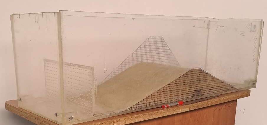
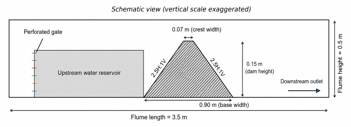
The laboratory setup consisted of a transparent plastic hydraulic flume 3.5 m long, 1.0 m wide, and 0.5 m high (Figure 2). The transparent side walls allowed visual observation of seepage flow and the phreatic surface. A 15-cm-high perforated distribution wall was installed upstream to stabilize the water movement. Openings for water discharge were provided downstream to prevent accumulation of seepage water.
A dam model made of loam soil was constructed in the central part of the flume (Figure 2). The model geometry was determined based on the prototype dam parameters: a height of 15 m, a crest width of 7 m, an upstream slope coefficient of , and a downstream slope coefficient of . Since the linear scale was adopted as 1:100, the model height was m, the crest width was m, and the calculated base length of the model m was practically consistent with the 0.90 m base length adopted in the experiment.
To separately investigate seepage in a homogeneous loam-soil body, some structural elements of the prototype dam were simplified in the experiment. In particular, the downstream drainage system, the concrete lining on the upstream slope, and the water outlet structure in the dam body were not included in the model. Therefore, these simplifications were taken into account when applying the results to the prototype structure.
Geometric similarity between the model and the prototype structure was ensured through the ratio of corresponding linear dimensions:
where and are the corresponding linear dimensions of the prototype structure and the model.
Water movement through the dam body was assessed based on soil hydraulic conductivity, the pressure difference, seepage-path length, and hydraulic gradient.
The density of the water used in the experiment was determined using a hydrometer and was 999.6 kg/m³. Water temperature was measured with a thermometer and recorded as 19.2 °C. This temperature was not a comparative indicator of different experimental regimes but a control parameter during the experiment.
The loam soil used for the model was placed in the flume in layers of uniform thickness and compacted evenly until the design shape was obtained. The bulk density of the soil was determined from the ratio of mass to volume and was 1650 kg/m³. Uniform placement and compaction of the layers helped prevent the formation of artificial local high-permeability channels. Previous studies have also substantiated the need to control soil properties to ensure the stability of hydraulic structures [15].
The granulometric composition of the soil was determined at the laboratory of the “Gidroproekt” Joint-Stock Company using sieve-pipette and hydrometric methods. The analysis was performed in accordance with the requirements of GOST 12536–2014 [11]. These results were used to identify the type of model soil and assess its susceptibility to seepage-related deformation.
Before the experiment, the dam model was formed using a 1×1 cm coordinate grid marked on the transparent side wall. The grid made it possible to record the water level, wetting-front position, phreatic-surface points, crest elevation, and profile deformations in a single coordinate system. Water was supplied upstream step by step, and its level was maintained at the model elevation corresponding to the prototype elevation of 487.68 m.
Water penetration into the soil body, expansion of the wetting zone, and movement of the phreatic surface were observed every 5 minutes. Observations continued until seepage water reached the downstream pool and the phreatic surface reached a conditionally stable state. At each stage, the coordinates of the phreatic surface, water levels, seepage outflow condition, and changes in the model profile were recorded. After the experiment, the crest elevation was compared with its initial state to determine vertical settlement. Approaches to the comprehensive assessment of dam settlement and seepage conditions under field conditions have been described in previous studies [14].
The coordinates of the phreatic surface obtained in the laboratory were converted to prototype values using the 1:100 scale and compared with observation data from section PC16+30. The main comparison criteria were the overall shape of the phreatic surfaces, piezometric heads within the dam body, and differences in the area near the downstream pool.
The average hydraulic gradient was determined as the ratio of the difference between piezometric heads in the upstream and downstream pools to the calculated seepage-path length:
where and are the piezometric heads in the upstream and downstream pools; is the calculated seepage-path length.
To evaluate the seepage strength and safety of the dam body in accordance with KMK 2.02.02–20 «Foundations of Hydraulic Structures» [12], the calculated hydraulic gradient must satisfy both the condition based on critical gradient () and the permissible gradient limit ():
During data processing, the phreatic surface, hydraulic gradient, and model crest settlement were analyzed as interrelated parameters.
Results and discussion
During the experiment, the upstream water level was maintained at a constant level corresponding to the Qamashi Reservoir elevation of 487.68 m. Water temperature was 19.2 °C, water density was 999.6 kg/m³, and the bulk density of the model soil was 1650 kg/m³. Seepage flow moved gradually through the dam body and reached the downstream pool after 41 hours. No washing of soil particles, suffusion, or local boiling was observed during the experiment.
The phreatic surface formed in the laboratory (Figure 3) showed a close overall configuration to the winter field observations at section PC16+30. In both cases, the phreatic surface decreased smoothly from the upstream pool toward the downstream pool. This indicates that the physical model qualitatively represented the main features of the seepage process. The importance of comparing physical and numerical model results with field data for assessing model reliability has also been noted in other studies [2, 17].
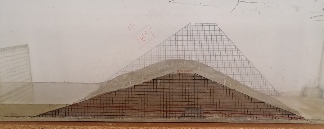
After completion of the experiment, 2 mm of vertical settlement was recorded at the model crest. No abrupt deformation, slope displacement, or distortion of the model profile was observed. However, this value represents only the model deformation under the adopted laboratory conditions and should not be directly equated with settlement of the prototype dam. Previous studies have also substantiated the need for comprehensive monitoring of seepage and deformation processes [13, 14].
With the calculated initial critical gradient , the condition of seepage strength according to Eq. (3) is expressed as:
The relative margin of safety with respect to the critical gradient is. This result shows that the average hydraulic gradient did not reach the limiting value under the experimental conditions. At the same time, the average gradient may not fully represent higher values occurring in individual local sections of the dam [3, 16].
The obtained results indicate that the 1:100-scale physical model can be used to study seepage flow and the phreatic surface in the dam body. However, the absence of drainage, concrete lining, and the water outlet structure in the model, as well as the fact that the experiment was conducted at a single water level and temperature, should be considered when interpreting the results. Changes in water level may affect the seepage field and pore-water pressure, as also shown in other studies [4].
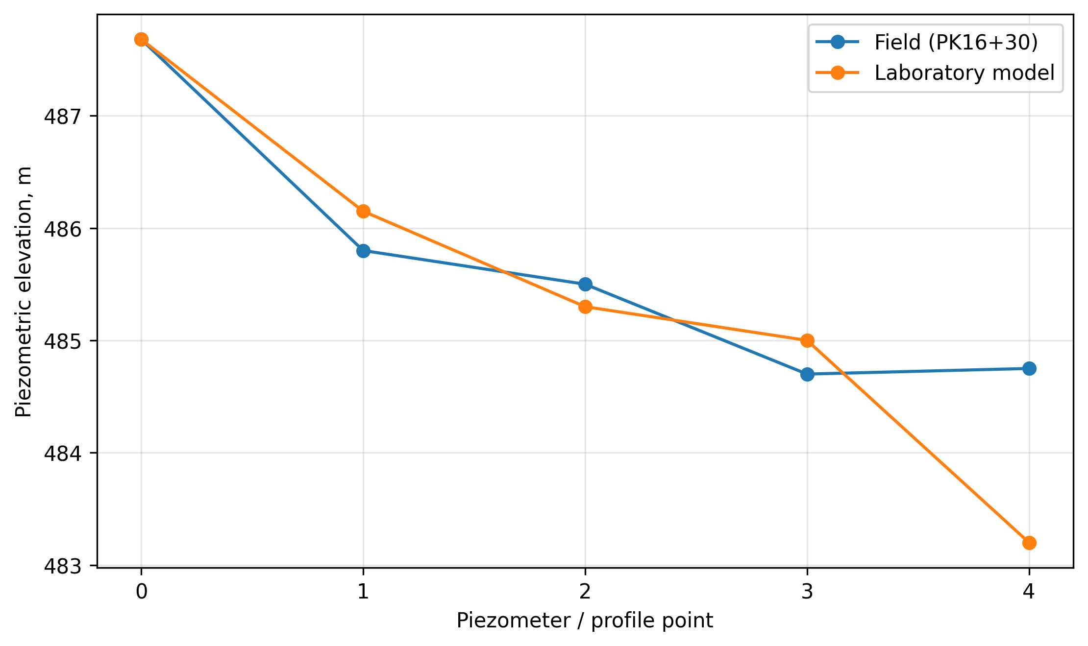
Figure 4 illustrates the comparative phreatic surface profiles. The horizontal axis represents the control piezometer profile points (from 0 at the upstream side to 4 at the downstream toe), and the vertical axis shows the piezometric head elevations measured in meters (m). As shown in Figure 4, the laboratory model profile closely tracks the field piezometric data points up to point 3, after which the absence of a drainage structure in the model leads to a steeper drop at point 4.
Conclusion
The seepage regime of the Qamashi Reservoir earth dam was investigated using a 1:100-scale physical model. During the experiment, water moved gradually through the dam body, and seepage flow reached the downstream pool after 41 hours. No washing of soil particles, suffusion, or local boiling was observed.
The phreatic surface formed in the laboratory showed a close overall shape to the field observations at section PC16+30. A vertical settlement of 2 mm was recorded at the model crest, while no abrupt deformation or slope displacement was observed. The calculated average hydraulic gradient was , which was below the adopted limiting values.
The results show that the physical model can be used for a qualitative assessment of seepage flow and the phreatic surface in the dam body. However, the absence of drainage, concrete lining, and the water outlet structure in the model, as well as the fact that the experiment was conducted under a single water-level and temperature condition, should be taken into account.
For further studies, it is recommended to repeat the experiments under different water levels and temperature conditions, determine local seepage gradients, and compare the results with numerical modeling and expanded field-monitoring data.
References