Оценка долгосрочных изменений минерализации грунтовых вод на орошаемых землях Республики Каракалпакстан
УДК 556.38+631.45
Abstract
The article examines the problems of studying, analyzing, and monitoring existing data on the hydrogeological, hydroecological, and reclamation state of groundwater dynamics in the irrigated lands of the Republic of Karakalpakstan. The research focuses on long-term changes (1990–2019) in groundwater levels and mineralization across 14 administrative districts of the Amu Darya delta, based on long-term observation data of the reclamation service of the Ministry of Water Resources of the Republic of Uzbekistan. Special attention is paid to the influence of intensive irrigation, filtration losses from the Amu Darya River, and anthropogenic factors on the hydrochemical regime and salinization processes of irrigated soils. Analysis of observational data showed that groundwater levels fluctuate significantly during the vegetation period, with the highest levels observed during leaching irrigations in spring. The predominant mineralization range is 1–3 g/l, occupying about 85 % of irrigated lands, a share consistent with recent basin-wide assessments. However, in some districts, mineralization reaches critical levels, exceeding permissible standards for irrigation water and contributing to secondary salinization. A statistical analysis (Pearson correlation, r = 0.75, R² = 0.56, p = 0.002) confirmed a significant positive relationship between average groundwater depth and mineralization across districts, reflecting reduced flushing and greater evaporative concentration of salts in poorly drained peripheral areas. The study reveals the main sources of groundwater recharge and discharge, the heterogeneity of hydrogeological conditions, and the role of natural and anthropogenic factors in salt accumulation. Practical recommendations are proposed for improving hydrogeological and hydroecological monitoring systems, optimizing irrigation and drainage networks, and reducing water losses to prevent further degradation of irrigated lands. These findings are essential for sustainable water resources management and increasing agricultural productivity in the arid conditions of Karakalpakstan.
Аннотация
В статье рассматриваются вопросы изучения, анализа и мониторинга имеющихся данных о гидрогеологическом, гидроэкологическом и мелиоративном состоянии динамики грунтовых вод на орошаемых землях Республики Каракалпакстан. Основное внимание уделено долгосрочным изменениям (1990–2019 гг.) уровня и минерализации грунтовых вод по административным районам дельты Амударьи. Особое внимание уделено влиянию интенсивного орошения, фильтрационных потерь из реки Амударья и антропогенных факторов на гидрохимический режим и процессы засоления орошаемых почв. Анализ данных наблюдений показал, что уровень грунтовых вод существенно колеблется в течение вегетационного периода, при этом наивысшие уровни отмечаются во время весенних промывных поливов. Преобладающий диапазон минерализации составляет 1–3 г/л и занимает наибольшую площадь орошаемых земель (около 85 %). Однако в отдельных районах минерализация достигает критических значений, превышающих допустимые нормы для оросительной воды, что способствует вторичному засолению. Статистический анализ (коэффициент корреляции Пирсона r = 0,75; p = 0,002) подтвердил значимую положительную связь между глубиной залегания и минерализацией грунтовых вод по районам. Исследование выявляет основные источники питания и разгрузки грунтовых вод, неоднородность гидрогеологических условий, а также роль природных и антропогенных факторов в накоплении солей. Предложены практические рекомендации по совершенствованию систем гидрогеологического и гидроэкологического мониторинга, оптимизации ирригационно-дренажных сетей и снижению потерь воды для предотвращения дальнейшей деградации орошаемых земель. Полученные результаты имеют важное значение для устойчивого управления водными ресурсами и повышения продуктивности сельского хозяйства в засушливых условиях Каракалпакстана.
Keywords: Amu Darya delta; groundwater mineralization; hydrochemical regime; hydroecological monitoring; hydrogeological monitoring; salinization; anthropogenic factors; statistical analysis.
Ключевые слова: дельта Амударьи; минерализация грунтовых вод; гидрохимический режим; гидроэкологический мониторинг; гидрогеологический мониторинг; засоление; антропогенные факторы; статистический анализ.
Introduction
Groundwater salinization and mineralization in the Amu Darya delta remain among the most pressing environmental problems of Central Asia and reflect a broader global groundwater crisis [13]. Recent district-level assessments show that in the Amudarya district alone the majority of irrigated land is affected by soil and groundwater salinity, with a substantial share classified as moderately to highly saline [8]. Comparable studies in the neighboring Khojeyli district have documented shallow, highly mineralized groundwater linked to irrigation return flow and insufficient drainage [5], while GIS-based approaches are increasingly used to map the spatial extent of salinized soils across Karakalpakstan [6]. Basin-wide climate-risk assessments further report that groundwater with mineralization of 1–3 g/l already covers more than 85 % of irrigated land in the Amu Darya river basin [16], a pattern that studies of secondary salinization attribute largely to reduced natural flushing of the lower delta [7]. Despite this growing body of work, systematic, multi-decade comparisons of groundwater level and mineralization dynamics across all administrative districts of the Republic of Karakalpakstan remain scarce, which limits the ability of water management agencies to prioritize districts for remediation.
The geological structure of the Amu Darya delta on the territory of the Republic of Karakalpakstan consists of various types and kinds of deposits from the Cretaceous, Tertiary, and Quaternary periods. Cretaceous deposits occur on the right bank of the river. Tertiary deposits are found near Tuyamuyun, the Kyzylkum Desert, the Ustyurt Plateau, and in other areas in the form of red and red-yellow clays.
Quaternary deposits are widely distributed throughout the territory of the modern and forming Amu Darya delta. They consist of sands, sandy loams, loams, and clays transported by water. These deposits are characterized by relatively good permeability, loose structure, and instability to flooding processes. Quaternary deposits serve as the main object of reclamation, within which groundwater is formed and its regime develops. Comparable patterns of groundwater formation in arid and super-arid deltaic environments of Central Asia and the Arabian Peninsula have been described elsewhere [11], and drought-related groundwater dynamics in Karakalpakstan were documented following the severe drought of 2001 [12].
Building on this background, the aim of this study is to assess long-term changes in groundwater levels and mineralization in the irrigated lands of the Republic of Karakalpakstan and to identify the main natural and anthropogenic factors influencing the salinization of irrigated soils. To achieve this aim, the following objectives were addressed: (1) reviewing the geological and hydrogeological structure of the Amu Darya delta; (2) analyzing groundwater level and mineralization dynamics across administrative districts for the period 1990–2019, including a statistical assessment of the relationship between depth and mineralization; (3) comparing the results with published regional and international studies; and (4) formulating practical recommendations for improving hydrogeological and hydroecological monitoring of irrigated lands.
Materials and Methods
In the course of the work, materials were collected on the depth of occurrence (groundwater level, GWL) and mineralization of groundwater in the irrigated territory, by administrative districts of the Republic of Karakalpakstan, for the period from 1990 to 2019, based on data from the reclamation service of the Ministry of Water Resources of the Republic of Uzbekistan. Groundwater level and mineralization data were obtained from the standing network of observation (piezometric) wells maintained by the reclamation service across the 14 administrative districts, with measurements taken seasonally during the irrigation period. Groundwater mineralization was determined by the dry-residue method routinely applied by the reclamation service laboratories and is expressed in g/l.
Groundwater depth and mineralization were compared against the classification of groundwater flow groups after N.N. Khodjibaev; the regional groundwater balance structure of the entire delta is presented and discussed in the Results section (Table 1). Hydrochemical data were further evaluated against the applicable water-quality standards — «Drinking Water» and «Water for Irrigation» — and the list of maximum permissible concentrations (MPC) of the NIGMI Institute and the classification of the Scientific-Research Institute of Irrigation and Water Problems. Recommended irrigation-water salinity thresholds by crop-tolerance class, following the international FAO classification, were also used for comparison (Table 3) [14].
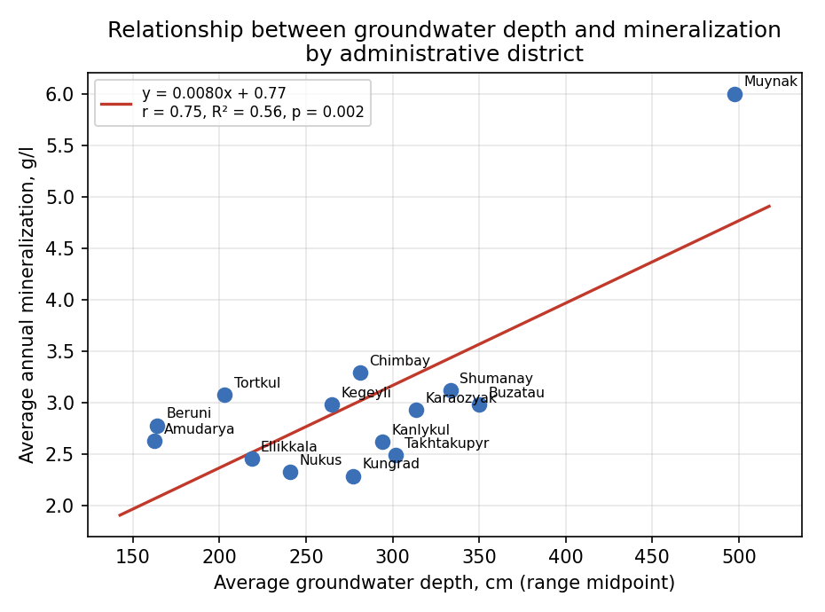
To characterize the relationship between average groundwater depth and mineralization at the district level, Pearson's correlation coefficient and simple linear regression were calculated across the 14 administrative districts for which data were available; statistical significance was assessed at p < 0.05 (Figure 2).
Results and Discussion
Analysis of the available data on the hydrogeological and reclamation conditions regarding the dynamics of groundwater in irrigated lands has shown that high groundwater levels are observed in March and April, during the period of intensive leaching irrigations. After the completion of leaching, a certain decline in the level occurs.
In terms of groundwater formation conditions, the lower reaches of the Amu Darya River differ from other oases in Uzbekistan in that the main river artery here runs along commanding elevations of the territory, forming groundwater flows moving from the river into the depths of the oasis.
On the irrigated area of 515.3 thousand hectares, groundwater at a depth of 0–1 m occupies 7.8 thousand ha; 1–1.5 m — 48.9 thousand ha; 1.5–2 m — 267.8 thousand ha; 2–3 m — 120.9 thousand ha; 3–5 m — 66.9 thousand ha; and more than 5 m — 2.25 thousand ha. Groundwater mineralization varies as follows: 0–1 g/l occupies 2.7 thousand ha; 1–3 g/l occupies 439.7 thousand ha (about 85 % of the irrigated area); 3–5 g/l — 72.8 thousand ha; 5–10 g/l — 6.06 thousand ha; and more than 10 g/l — 0.3 thousand ha. The uneven distribution of irrigated land within the predominant 1–3 g/l mineralization range among districts is illustrated in Figure 1.
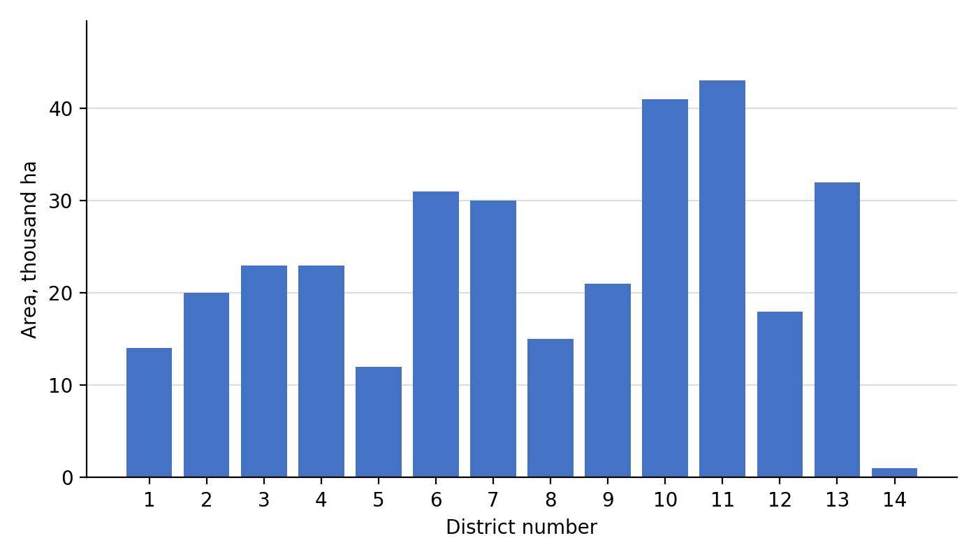
District numbers: 1 — Tortkul, 2 — Ellikkala, 3 — Beruni, 4 — Amudarya, 5 — Khojeyli, 6 — Shumanay, 7 — Kanlykul, 8 — Kungrad, 9 — Nukus, 10 — Kegeyli, 11 — Chimbay, 12 — Karaozyak, 13 — Takhtakupyr, 14 — Muynak.
Groundwater saturating the thickness of deltaic deposits and almost devoid of general runoff forms an extensive basin with heterogeneous hydrogeological conditions. This heterogeneity is expressed in differences in the depth of groundwater occurrence, their mineralization, and conditions of local runoff, depending on recharge, relief, and lithological composition of the rocks.
In the formation of delta groundwater, the river itself and its tributaries play the main role. Atmospheric precipitation contributes a noticeable share to groundwater recharge only in spring on areas with shallow occurrence. Groundwater is mainly consumed by evaporation. Underground runoff is of subordinate importance, depending on local lithological and geomorphological conditions. Areas with more or less well-expressed local underground runoff are located near the river and its tributaries [1–3].
Peripheral parts of the delta, near the Ustyurt Plateau in the west and in the Takhtakupyr district in the east, are characterized by usually deep groundwater occurrence (below 10 m), where evaporation is extremely weakened.
Within the areas near the Aral Sea, characterized by an abundance of frequently changing river channels, floods, and lakes, groundwater occurs at shallow depths (usually no deeper than 3 m). Local underground runoff in these parts of the delta is noticeably expressed along active channels (of the river and its tributaries), which serve as sources of groundwater recharge. The underground runoff directed from the channels into the depth of the coastal strip quickly attenuates (at tributaries within several hundred meters, and at the main river channel — 1–2 km), since in most cases it occurs under conditions of shallow groundwater occurrence, which evaporates in significant quantities along the flow path.
The structure of the regional groundwater balance of the entire delta from Tuyamuyun to the Aral Sea (without taking irrigation into account) characterizes the basin as a territory of natural salt accumulation and is presented in Table 1.
Groundwater mineralization in the stagnation zone is variegated; an uneven distribution of salts is observed, which mainly depends on the presence of local underground runoff [2–3].
Table 1. Structure of the regional groundwater balance (m³/s) of the entire delta from Tuyamuyun to the Aral Sea (without taking irrigation into account), which characterizes the basin as a territory of natural salt accumulation.
| Income | Value | Expenditure | Value |
|---|---|---|---|
| Losses from the Amu Darya River (excluding overflow) | 320 | Underground runoff | 0 |
| Atmospheric precipitation | 30 | Total evaporation, rise in groundwater levels, and return to the river | 350 |
| Underground tributary | 0 | ||
| Total | 350 | 350 |
The lowest mineralization is characteristic of groundwater in the near-river strip and areas adjacent to the channels. Hydrocarbonate-sulfate calcium waters predominate here, while directly near watercourses, hydrocarbonate calcium waters are prevalent. As the total salt content in the water increases — particularly sharply expressed in the middle parts of inter-channel depressions — the content of sulfates and chlorides rises. In highly mineralized waters (40–60 g/l), chlorides predominate. Among cations, sodium and magnesium are dominant.
In the vertical profile, groundwater mineralization is also variable. It is freshened by filtration waters of the Amu Darya River and its tributaries through local underground runoff. Finally, saline, especially Tertiary, rocks of the bedrock often cause increased mineralization of groundwater in the lower part of the aquifer. Therefore, in some cases, mineralization decreases with depth, while in others it increases.
When considering the conditions of groundwater occurrence, it is easy to notice the specific structure of the aquifer in deltaic deposits. Sandy formations of channel facies are widely developed within the delta body. As a result of the wandering of the river and its tributaries, channel facies were buried under flood and lake facies, represented by a layered complex of sandy loams, loams, and clays containing interlayers of fine-grained sand. Channel deposits within the delta body have a multi-tiered structure.
Due to the variability of the hydrographic network directions throughout its development history, the horizontal projections of ancient buried and modern channels intersect in a complex manner.
Channel facies are of great interest as potential sites for natural collectors (in the case of creating a regional lowering of the groundwater table through well pumping). These areas are also the most favorable for the localization of underground, albeit weak, runoff.
According to the works of N.N. Khodjibaev, several groups of groundwater flows are distinguished in the basin territory.
A. Group of groundwater flows of the left bank of the Amu Darya. It is located in the western part of the basin, on the territory of the Priaral part of the Amu Darya delta. Its boundaries in the east and southeast run along the Amu Darya, in the south — along the outcrops of bedrock through the «Nazymkhan» protrusion to the «Akkelin» plateau, in the west along the chink of the Ustyurt, in the northwest along the 40th hydroisohypse, which is the boundary of the described flow with the groundwater flow from Lake Sudochye, and in the north (conditionally) along the line of the modern forming delta.
Sources of groundwater recharge are filtration losses of surface runoff and infiltration of atmospheric precipitation. In some areas in old channels, in Cretaceous and Quaternary deposits, lenses of fresh water with mineralization up to 1 g/l are observed. Groundwater mineralization increases from the recharge zone to the discharge zone from fresh to brackish-saline (from 0.5 to 50–60 g/l).
B. Group of groundwater flows of the modern Aral delta. It is located in the northwestern part of the basin. In the west it is bounded by the Amu Darya, in the north by the modern forming delta, in the northeast the boundary runs along the southwestern slope of the Beltau upland, and in the southeast along the Tabakum sands. Sources of groundwater recharge are filtration waters of temporarily and permanently operating watercourses and, to some extent, infiltration of atmospheric precipitation.
The depth of groundwater occurrence varies from 1–5 to 10–20 m. Mineralization changes from 0.5 g/l (in the recharge zone) to 10–50 g/l (in the discharge zone). In the area of this group of flows, the process of vertical water exchange predominates. The territory is naturally poorly drained, and in the lower part, where evaporation predominates over runoff, it is undrained.
Group of groundwater flows of the northern slopes of the Sultan-Uiz-Dag Mountains. It is located in the southeastern part of the described basin. Sources of groundwater recharge are surface waters of the Amu Darya, atmospheric precipitation, and overflow from bedrock deposits. The waters are characterized by low mineralization (from 0.5 to 1.5 g/l) in the old channels of the Amu Darya and increased mineralization (up to 10–15 g/l) on the sandy plain [2–4]. In the recharge zones, groundwater occurs at elevations of 95–105 m, and in the discharge zones — at 40 m. The direction of flow movement is from south to north and northeast. Due to hindered underground runoff and the climatic conditions of the area, groundwater is mainly consumed by evaporation and plant transpiration. A small amount of water is discharged as underground outflow toward the Sarykamysh depression. Outflow is somewhat improved along the channels of old riverbeds.
The mineralization of groundwater in the oasis depends on the nature of groundwater recharge and discharge and their connection with the river. Mineralization varies from 0.5 to 5 g/l and higher. The least mineralized waters are developed along the Amu Darya old channels of Daryalyk and Daudan, while the most mineralized waters are mainly distributed beyond the oasis. This indicates a significant movement of water masses, and consequently salts, within the delta under the influence of natural geological factors.
The hydrochemical profile throughout the territory of the Pri-Sarykamysh delta has one form: a certain increase in mineralization at the groundwater table, a decrease in the interval of 5–15–25 m, and an increase again with depth.
In terms of chemical composition, groundwater changes from hydrocarbonate-sulfate to chloride-sulfate types. The ratio of groundwater recharge to evaporation determined the features of the chemical composition — intensive accumulation of chlorides in the oasis groundwater.
For the basin territory, the distribution of groundwater with a table depth from 1–2 to 30 m is characteristic. The closest occurrence of the level is observed in the near-Amu Darya strip; with distance toward its periphery, it deepens, and in the desert part of the delta it is at a depth of over 15 m.
Groundwater discharge on the left bank occurs due to evaporation, transpiration, and underground outflow toward the Sarykamysh depression, partially by wedging out in the area of lakes in southern Khorezm. In the Akchadarya delta, discharge occurs through evaporation, transpiration, and partially by wedging out into Lake Ashikkul.
According to data from the reclamation service of the Ministry of Water Resources of the Republic of Uzbekistan, lands with medium and strong degrees of salinization in the Republic of Karakalpakstan constituted 40 to 50 % of the irrigated territory in different years, with strong salinization ranging from 22.7 to 64.5 thousand ha (in Khorezm — from 12 to 39 thousand ha). If such lands are left without leaching, it is generally impossible to obtain a harvest. Seasonal salinization depends on groundwater depth, irrigation regime, and technology during cotton vegetation, typically intensifying toward the end of the vegetation period as evaporative concentration of salts in the upper root zone increases; comparable seasonal water-salt regime patterns and the need for regulated leaching and drainage have been described in other Karakalpakstan and Khorezm studies [9, 10, 15]. With insufficient supply of irrigation water from above and unsatisfactory drainage of territories, salts accumulate in the upper root zone by the end of the vegetation period. Salinization is the result of suboptimal water resources management, leading to significant losses in the yield of cotton and other agricultural crops. Unsatisfactory drainage contributes to groundwater stagnation, but the main reason for the rise in groundwater levels is large water losses from canals and fields during irrigation of agricultural crops.
The average groundwater level and mineralization in the irrigated zone of the Republic of Karakalpakstan by administrative district (2018 and recent years) are summarized in Table 2. It is evident that within reclamation systems, the average annual groundwater level varies from 133 to 743 cm. It should be noted as a limitation of this study that district-level observation data for Khojeyli district were not available for the analyzed period; this district is therefore omitted from Table 2, and closing this gap is recommended as a direction for future monitoring and follow-up research.
Table 2.
Average groundwater level and mineralization by administrative district of the Republic of Karakalpakstan.
| District | Groundwater level range, cm | Average annual mineralization, g/l |
|---|---|---|
| Tortkul | 171–235 | 3.08 |
| Ellikkala | 179–258 | 2.46 |
| Beruniy | 133–195 | 2.78 |
| Amudarya | 137–188 | 2.63 |
| Shumanay | 179–488 | 3.12 |
| Kanlykul | 160–428 | 2.62 |
| Kungrad | 176–378 | 2.29 |
| Muynak | 252–743 | 6.00 |
| Nukus | 185–297 | 2.33 |
| Kegeyli | 165–365 | 2.98 |
| Buzatau | 215–485 | 2.98 |
| Chimbay | 172–390 | 3.29 |
| Karaozyak | 175–452 | 2.93 |
| Takhtakupyr | 192–411 | 2.49 |
| Republic-wide average | 185–357 | 3.00 |
Statistical analysis. Across the 14 districts for which data were available, average groundwater depth (midpoint of the reported range) and average mineralization show a moderate-to-strong, statistically significant positive correlation (Pearson r = 0.75; R² = 0.56; simple linear regression: mineralization (g/l) = 0.008 × depth (cm) + 0.77; p = 0.002, n = 14; Figure 2). This indicates that districts with deeper and more variable groundwater tables — such as Muynak, where levels fluctuate between 252 and 743 cm — tend to have higher mineralization, consistent with reduced flushing, longer residence time, and greater evaporative concentration of salts in poorly drained peripheral areas of the delta. In contrast, districts with the shallowest, near-river groundwater, such as Amudarya and Beruni, show comparatively lower mineralization, consistent with active freshening by filtration losses from the Amu Darya.
Recommended mineralization thresholds for irrigation water. According to the internationally recognized FAO classification of irrigation water quality [14], the salinity hazard of irrigation water is commonly classified by electrical conductivity (EC) and the approximately corresponding total dissolved solids (mineralization), as summarized in Table 3. Comparing these thresholds with the district-level data in Table 2 shows that average mineralization in most districts of the Republic of Karakalpakstan (2.3–3.3 g/l) falls within the range associated with severe restriction on use for salt-sensitive crops, while in Muynak district (6.0 g/l) mineralization exceeds the range generally considered usable even for tolerant crops without specific leaching and drainage management.
Table 3.
Classification of irrigation water salinity hazard (adapted from Ayers & Westcot, FAO Irrigation and Drainage Paper 29, 1985) [14].
| Degree of restriction on use | EC, dS/m | Approx. mineralization, g/l |
|---|---|---|
| None | < 0.7 | < 0.45 |
| Slight to moderate | 0.7 – 3.0 | 0.45 – 2.0 |
| Severe | > 3.0 | > 2.0 |
Comparison with other regional studies. The finding that groundwater mineralization of 1–3 g/l covers about 85 % of the irrigated area of the Republic of Karakalpakstan (439.7 of 515.3 thousand ha) is consistent with a recent basin-wide climate-risk assessment, which reported the same mineralization range covering more than 85 % of irrigated land across the entire Amu Darya river basin [16]. District-level studies in Khojeyli [5] and Amudarya [8] districts likewise report shallow, moderately to highly mineralized groundwater linked to irrigation return flow and insufficient drainage, corroborating the mechanisms described above. Long-term hydrological studies further indicate that the flow of the Amu Darya in its middle and lower reaches has declined markedly over recent decades, an effect attributed mainly to expanding upstream water withdrawals rather than to climate change alone [17]. A continued reduction in river discharge would be expected to reduce filtration recharge of the near-river groundwater flow described above, potentially weakening the natural freshening that currently keeps mineralization lowest along the river corridor; monitoring this relationship is recommended as a priority for future research.
Conclusion
On the irrigated area of 515.3 thousand hectares, groundwater at a depth of 0–1 m occupies 7.8 thousand ha; 1–1.5 m — 48.9 thousand ha; 1.5–2 m — 267.8 thousand ha; 2–3 m — 120.9 thousand ha; 3–5 m — 66.9 thousand ha; and more than 5 m — 2.25 thousand ha. Groundwater mineralization varies as follows: 0–1 g/l occupies 2.7 thousand ha (0.5 %); 1–3 g/l occupies 439.7 thousand ha (about 85 % of the irrigated area, consistent with recent basin-wide estimates); 3–5 g/l — 72.8 thousand ha (14.1 %); 5–10 g/l — 6.06 thousand ha (1.2 %); and more than 10 g/l — 0.3 thousand ha (0.1 %). A statistically significant positive relationship (Pearson r = 0.75, R² = 0.56, p = 0.002) between average groundwater depth and mineralization across districts confirms that deeper, poorly drained groundwater in the peripheral parts of the delta is associated with higher salt content.
The conducted analysis of hydrochemical data of groundwater over recent years shows that mineralization and the content of individual ions and microelements exceed the permissible levels according to the standards «Drinking Water» and «Water for Irrigation,» the list of maximum permissible concentrations (MPC) of the NIGMI Institute, and the classification of the Scientific-Research Institute of Irrigation and Water Problems. This leads to the violation of the hydroecological state of irrigated territories. Given the documented long-term decline in Amu Darya discharge in its middle and lower reaches over recent decades, mainly attributed to expanding upstream water use [17], continued hydrogeological and hydroecological monitoring, together with optimization of irrigation-drainage networks and reduction of water losses, is essential to prevent further degradation of irrigated land in the Republic of Karakalpakstan.
References