PhD, Senior Researcher, Director, Karakalpak Branch of the Scientific Research Institute of Irrigation and Water Problems, Uzbekistan, Nukus
E-mail: kurbanbaev69@mail.ru
http://orcid.org/0000-0002-6772-7453

УДК 556.53:556.166:574.5
The article gives an analysis of long-term (1965–2022) trends in the river flow regime of the Amudarya, peak discharges at the Kiziljar hydrological station (as an inflow to the three largest reservoirs in the Amudarya delta: Mezhdurechie, Moynaq, and Ribachie), and actual storage capacities of these reservoirs based on field GPS leveling data and ArcGIS bathymetric modeling. The Visual C# mathematical water balance model was used to explore the water resources of the investigated delta reservoirs under different inflow scenarios. It was found that the natural flow of the Amudarya was reduced by half in 1965–2006 (390 m3/s), with the peak outflow at Kiziljar being 714.1 m3/s (3 %-exceedance probability discharge). The water balance calculations for the 2010 wet, 2019 average, and 2001 dry years showed that Kiziljar reservoirs require a minimum annual inflow of 515.55 Mm3 to store water in all three reservoirs. The GPS survey leveling and ArcGIS slope analysis results indicated that the actual storage capacity of the Kiziljar reservoirs is 12–17.5 % below the designed capacity due to severe silting. At the same time, hydrobiological monitoring in 2022–2023 revealed a reduction in zooplankton species richness by 34 % (from 40 to 27 species) compared to previous studies: 15 species of Rotifera, 6 species of Cladocera, and 6 species of Copepoda. The obtained results can serve as the basis for developing a hydrological and water use management strategy for the Aralo-Caspian region with the changing flow of the Amudarya.
В статье проводится анализ долгосрочных (1965–2022) тенденций режима речного стока Амударьи, пиковых расходов на гидрологическом посту Кизилджар (как притока в три крупнейших водохранилища в дельте Амударьи: Междуречье, Мойнак и Рыбачье) и фактических емкостей этих водохранилищ на основе данных полевого GPS-нивелирования и батиметрического моделирования в ArcGIS. Для исследования водных ресурсов изучаемых дельтовых водохранилищ при различных сценариях поступления воды использовалась математическая модель водного баланса на Visual C#. Установлено, что естественный сток Амударьи сократился вдвое в период 1965–2006 гг. (390 м³/с), при этом пиковый расход на посту Кизилджар составил 714,1 м³/с (расход при 3 %-ной вероятности превышения). Расчеты водного баланса для влажного 2010 г., среднего 2019 г. и сухого 2001 г. показали, что водохранилищам Кизилджара требуется минимальный годовой приток 515,55 млн м³ для накопления воды во всех трех водохранилищах. Результаты GPS-нивелирования и анализа уклонов в ArcGIS указали, что фактическая емкость водохранилищ Кизилджара на 12–17,5 % ниже проектной емкости из-за сильного заиления. Одновременно гидробиологический мониторинг в 2022–2023 гг. выявил снижение видового богатства зоопланктона на 34 % (с 40 до 27 видов) по сравнению с предыдущими исследованиями: 15 видов Rotifera, 6 видов Cladocera и 6 видов Copepoda. Полученные результаты могут служить основой для разработки стратегии гидрологического и водохозяйственного управления Арало-Каспийского региона с учетом изменяющегося стока Амударьи.
Keywords: Amudarya delta; hydrological regime; peak water discharge; reservoir; water balance; GIS; zooplankton.
Ключевые слова: дельта Амударьи; гидрологический режим; пиковый расход воды; водохранилище; водный баланс; ГИС; зоопланктон.
The rational use of water resources is one of the most pressing problems in Central Asia today. The natural flow of water in the Amudarya River has changed significantly in the last few decades due to the active use of water for irrigation and climate change [1, p. 156; 3]. In the 1960s, the Amudarya River flowing into the Aral Sea was reduced by more than half in its lower reaches [1, p. 156].
In the 1950s, more than 140 large lakes in the Amudarya delta, covering an area of about 600 km², were formed [7]. By 2022, the number of these lakes had decreased twice, the tugai forests ten times, and the reed beds – 40 to 50 times [8, p. 29]. As a result of the Aral Sea’s catastrophic drying up, three reservoirs were built in the former bed of the Amudarya River in Karakalpakstan to ensure the water supply of the local population, fisheries, and ecosystems. The Mezhdurechie reservoir was commissioned in 1978; the Moynaq and Ribachie reservoirs – in 1974 [2, p. 153; 9].
At the same time, with the reduction of stream flow, there is a threat to the reservoirs’ functioning: on the one hand, they cannot be filled with water during droughts, and on the other hand, peak flows of up to 3,530 m³/s threaten to destroy the dam structure (for example, in Kiziljar in July 1969) [4, p. 176; 9]. The dam of the Mezhdurechie reservoir is designed for a maximum flood of 59.00 m asl (57.30 m asl – designed level), which corresponds to a 3 % probability of exceeding [4, p. 176; 9]. This study examines the hydrological and ecological issues of the Amudarya delta reservoirs, which is of great importance for the Republic of Uzbekistan. Presidential Decree No. PD-5202 of July 29, 2021, designates the Aral Sea region as the “Ecological Innovation and Technology Zone.” This decree allocated specific tasks to study and stabilize the delta water bodies (Paragraph 16). However, the existing knowledge about the studied reservoirs is limited to the results of previous studies [2, p. 153]. In particular, a long-term hydrological assessment of the Kiziljar flow gauging station (1965 – 2022) and a morphological description using modern surveying methods have not been performed. The current state of the zooplankton complex was last studied more than ten years ago [5].
The objective of this study is to assess the long-term trends in the flow of the Amudarya River, the morphological characteristics of the reservoirs, and the state of their ecosystems. In particular, the following tasks were set: 1) to analyze the trends in annual and peak flows of the Amudarya River for the period 1965 – 2022; 2) to determine the morphological characteristics of the reservoirs; 3) to simulate the water balance of the reservoirs for wet, average, and dry years; 4) to study the zooplankton complex as an indicator of the hydrological and ecological state of the reservoirs.
2.1. Study objects. The study was conducted on three reservoirs in the Central (Amudarya riparian) zone of the Amudarya delta in Karakalpakstan, Uzbekistan. The Mezhdurechie reservoir (17,863 ha, 191.0 M m³) is located in the inter-channel area between the Oqdarya and Qipchoqdarya distributaries and receives water from the Amudarya River through the Takhiatash hydraulic structures. The Moynaq reservoir (12,529 ha, 184.9 M m³) is fed by the Glavmyaso canal, while the Ribachie reservoir (6,243 ha, 124.9 M m³) is located in the former Saribas Bay and is supplied with water from the Marinkinyuzyak canal [9, 4].
The Kiziljar flow gauging station is located about 55 km downstream of the Takhiatash headworks and provides information on the flow of water entering the Mezhdurechie reservoir.
2. 2. Hydrological analysis. The streamflow data of the Amudarya River at the Kiziljar station for the period 1965 – 2022 (58 years) were used to analyze the long-term trends in the river flow. The exceedance probability curve was constructed using the Chegoday formula: P = (m − 0.3) / (n + 0.4) × 100 %, where m is the rank, n is the number of observations. The following hydrological characteristics were calculated: the multi-year average discharge Q0 (m³/s), variation coefficient Cv, and the coefficient of skewness Cs [12].
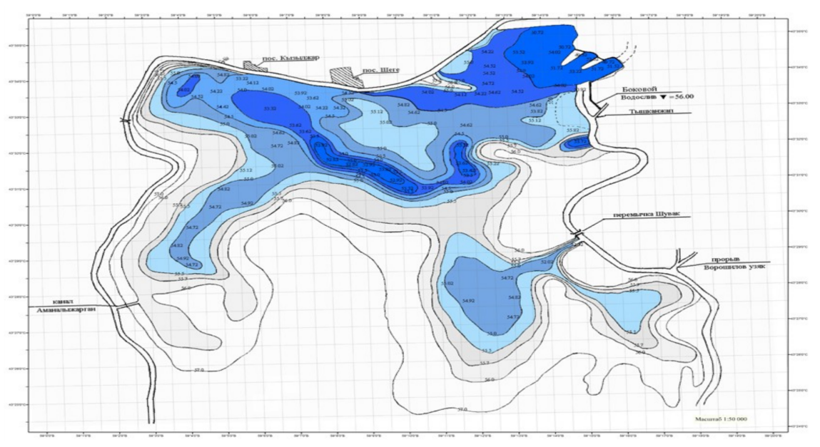
2. 3. Morphometric surveys. In 2022 – 2023, the morphological characteristics of the reservoirs were studied using high-precision GPS leveling. The study involved dividing the reservoirs into transects (Mezhdurechie – 6 transects; Moynaq – 8 transects; Ribachie – 6 transects). In each transect, absolute heights and coordinates were measured, and an isobath map was made in ArcGIS 10.7 software. Using this map, the relationships between the reservoir’s area and volume were determined as functions of the water level ω = f (H) and V = f (H). The volume was calculated using the formula V = Σ (Wi + Wi+1) / 2 × Δhi, where Wi is the area at the i-th contour, and Δhi is the interval between adjacent contours [6, 9].
2. 4. Mathematical water-balance modeling. A water balance model of the three-reservoir system was developed in the Visual C# programming language. The basic equation for calculating the change in storage for each reservoir is presented by the following differential equation: dWi/dt = Qp – qr – qe – q_f ± qo, where Qp is the inflow of water into the reservoir from the Amudarya River; qr – channel losses; qe – reservoir outflow due to evaporation; q_f – filtration losses; qo – outflow of water through connecting structures or between reservoirs. To determine the input characteristics for the water balance model, the average monthly flow of the Amudarya River was used, measured at the Samanboy flow gauging station. For the calculations, three scenarios were used: a wet year (2010 – 16,817.7 M m³), an average year (2019 – 1,674.4 M m³), and a dry year (2001 – 100.9 M m³) [6].
2.5. Hydrobiological surveys. In 2022 and 2023, during the summer and autumn seasons, zooplankton surveys were carried out. In total, 32 samples were taken (23 – quantitative and 9 – qualitative) with a conical plankton net (mesh size – 76). Water was taken from the nets by passing 100 L of water through them or by towing. The samples were fixed in 2-3% formalin solution. Zooplankton was counted and identified using a binocular microscope. The results of the quantitative analysis were used to determine the number of individuals per cubic meter of water (ind./m³) and the biomass in milligrams per cubic meter (mg/m³) [10, 11]. Using the individual weight-length relationship, the biomass was calculated [16, p. 183].
The analysis of the Kiziljar station data for the period 1965 – 2022 shows a long-term decline in the flow of the Amudarya River into the delta (Table 1). In particular, for the period 1965 – 2006, the average annual discharge decreased from 390 to 177.5 m³/s, and for the period 1980 – 2021 – from 350 to 177.5 m³/s. The absolute maximum monthly average flow was recorded in July 1969 and amounted to 3,530 m³/s. Since 1998, the flow has not been so high in the Amudarya River. At the same time, a decrease in flow below 50 m³/s was noted in 2001, 2006 – 2008, 2014, 2018, and 2021 (Figure 1).
Table 1.
Selected mean annual discharges and exceedance probabilities at Kiziljar gauging station, 1965–2022 [2, p. 153; 9]
| Year | Mean Annual Flow, m³/s | Exceedance Probability, % |
|---|---|---|
| 1965 | 1,038.0 | 1 |
| 1969 (max) | 1,781.0 | ~1 |
| 1980 | 271.0 | 2 |
| 1988 | 516.6 | 9 |
| 1992 | 675.3 | 4 |
| 1998 | 714.1 | 2 |
| 2000 | 66.3 | 61 |
| 2001 (min) | 2.8 | 98 |
| 2010 | 484.2 | 11 |
| 2019 | 39.0 (avg) | 70 |
| 2022 (est.) | 4.0 | 94 |
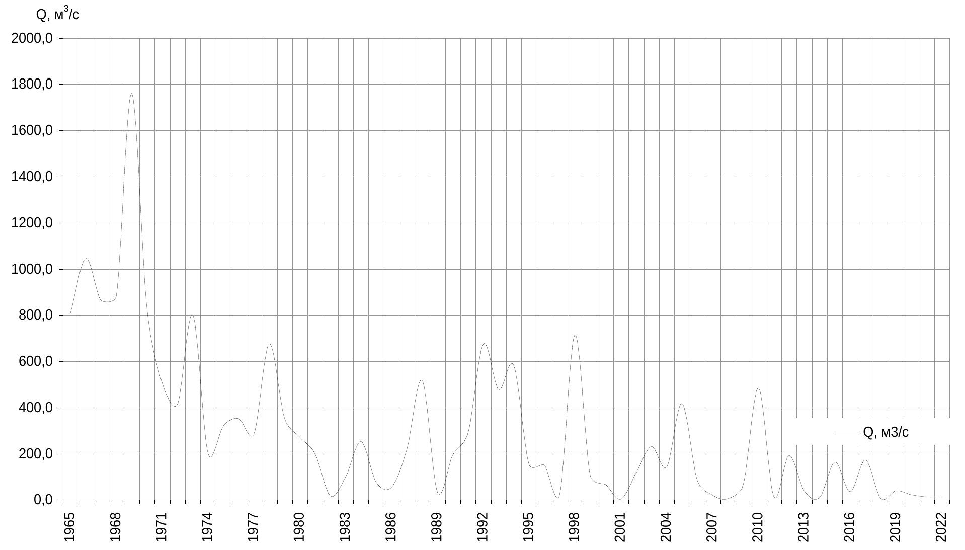
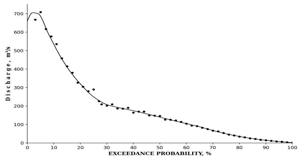
From the frequency curve (figure 2), the 3 % exceedanceprobability discharge, which is the design peak for Mezhdurechie dam, is equal to 714,1 m³/s. Optimisation of the joint operating regime of the Tuyamuyun reservoir and the Takhiatash headwork allows to reduce the peak of the flood wave transferred to the delta by 12 – 15 %. This confirms the calculations of Kurbanbaev [2, p. 153] performed on the data of the 2006 available up to the time of the study.
Determination of actual morphometric characteristics of the reservoirs using GPS leveling and mathematical modeling in ArcGIS gave the results presented in Table 2. In all three reservoirs, the volumes accounted for less than the design ones: Mezhdurechie – 83 %, Moynaq – 88 %, Ribachie – 82,5 %. The reason for this is the silting of intake structures and shoaling of the reservoirs’ bottom.
Table 2.
Actual and project morphometric characteristics of the Amudarya delta reservoirs (field surveys 2022-2023)
| Reservoir | Actual Area (ha) | Design Area (ha) | Actual Volume (M m³) | Design Volume (M m³) | Mean Depth (m) |
|---|---|---|---|---|---|
| Mezhdurechie | 17,863 | 21,436 | 191.0 | 230.0 | ≈2.5 |
| Moynaq | 12,529 | 15,034 | 184.9 | 210.0 | 1.48 |
| Ribachie | 6,243 | 7,304 | 124.9 | 151.4 | 2.0 |
| Total | 36,635 | 43,774 | 500.8 | 591.4 | — |
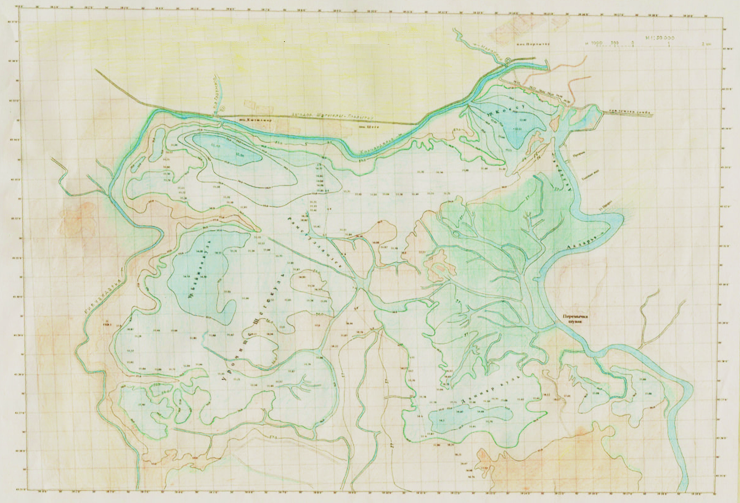
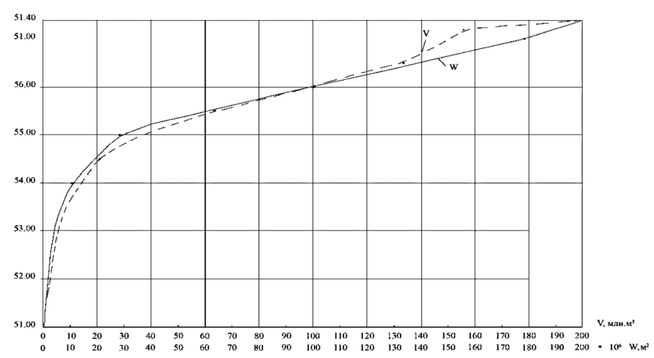
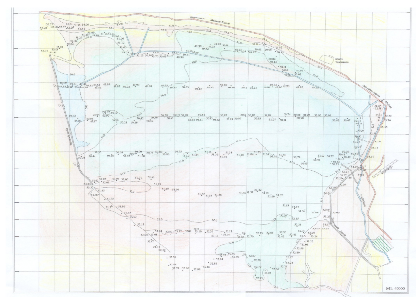
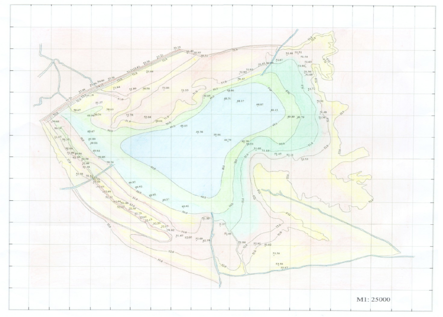
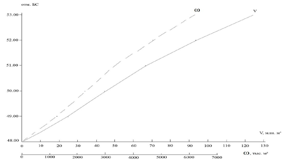
Bathymetric maps of the reservoirs are shown in Figs. 3–7. By comparing the isobathes of Mezhdurechie in 2002 (Fig. 3) and 2022 (Fig. 4), one can observe that the deep water areas are shifted to the south compared to the 2002 boundaries, especially in the west and south-west which is explained by the priority of the Oqdarya inflow with its suspended load. On the other hand, the areal – volume curves (Figs. 5,7,8) are used in the operational management of the reservoirs by the Department of Reservoir Regulation.
The results for the chosen three years are summarised in Table 3. It can be seen that the total amount of inflows for the wet year of 2010 accounted for 16,817.7 M m3, which significantly exceeded the reservoirs’ total storage capacity of 499.9 M m3. This means that about 12,214.9 M m3 (or 72.7%) of the total inflows have been diverted to the former Aral Sea bed (a draught region), which is a major concern for the water-resources management in the basin. On the contrary, in the average year of 2019, the total inflows only amounted to 1,674.4 M m3, which was enough to fill all the three reservoires to the brim with a remaining 852.4 M m3 (50.9%) spilled away downstream. Finally, in the dry year of 2001, the inflows were only 100.9 M m3 as compared to the needed minimum of 515.55 M m3, which caused a deficit of 399.1 M m3.
Table 3.
Water-balance components of the Amudarya riparian zone for the three years
| Component | Wet year 2010 | Average year 2019 | Dry year 2001 |
|---|---|---|---|
| Annual inflow volume, M m³ | 16,817.7 | 1,674.4 | 100.9 |
| Channel transmission losses, M m³ | 4,204.4 | 418.6 | 25.2 |
| Useful reservoir storage (3 res.), M m³ | 499.9 | 499.9 | 184.2 |
| Total evaporation, M m³ | 287.1 | 100.4 | 4.95 |
| Discharge to former Aral Sea bed, M m³ | 12,214.9 | 852.4 | 0.0 |
| Required optimal annual inflow, M m³ | — | — | 515.6 (norm) |
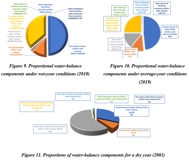
The obtained results have particular importance in terms of engineering infrastructure. Thus, the complete restoration of the Glavmyaso canal (15 – 20 m3/s instead of 44 m3/s in the project) and the Marinkinyuzyak canal (20 instead of 50) will increase the overall storage capacity by 669.5 million m3 (reaching 1169.5 million m3 in total). This will significantly alleviate the problem of outflows even in the case of a wet year [4, p. 176; 9].
By comparing the obtained results with similar research presented by Kurbanbaev [2, p. 153], one can notice that the amount of freshwater outflows decreased by more than half, and the number of years with extremely low outflow rates significantly increased. In other words, the results confirm the validity of the norms adopted in the abovementioned study, which are now used to process 16 years of hydrological data instead of 6.
In total, 27 species of zooplankton were identified in the waters of the three reservoirs during the 2022/2023 survey expeditions (Table 4). Among them, 15 species (55.6 %) belong to the class Rotifera, 6 species (22.2 %) – to the class Cladocera, and 6 species (22.2 %) – to the class Copepoda. Notably, 7 species of zooplankton were found for the first time in the waters of the lower Amudarya: Hexartra mira, Asplanchna sieboldi, Polyarthra vulgaris, Bdelloida gen. sp., and others.
Table 4.
Zooplankton biodiversity in the delta reservoirs of the Amudarya River (2022-2023)
| Taxonomic group | No. of species | Mezhdurechie share, % | Ribachie share, % | Moynaq share, % |
|---|---|---|---|---|
| Rotifera | 15 (56%) | 57–88 | 60 | 70 |
| Cladocera | 6 (22%) | 22 | 20 | 16 |
| Copepoda | 6 (22%) | 21–45 | 20 | 14 |
| Total | 27 | 100 | 100 | 100 |
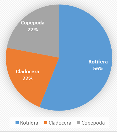
The species richness was found to decrease by 34 % compared to the 2003 – 2004 baseline (41 species) [17, p.10] and by 25 % compared to the 1968 – 1983 baseline (36 species, excluding Rotifera) [5, p.585]. The strongest deviation was observed in the Ribachie and Moynaq reservoires, where salinity increased to 1.5 – 4.0g/L, resulting in proliferation of salt-adapted rotifers (up to 70,000 ind./m3 in Moynaq reservoir in summer 2023) and a decrease in the number of freshwater stenohaline species. The absolute biomass of zooplankton reached the maximum in the Mezhdurechie reservoir (4,400 mg/m3 in August), which may be associated with more predictable hydrological regime [18].
This trend of community simplification and replacement of freshwater specialist species by generalists tolerant to increased salinity can be regarded as typical for the remnants of the former Aral Sea [13, p.83; 14]. Its detection in the study area qualifies as an early warning signal of impending changes in water quality. Therefore, it is advisable to conduct hydrobiological monitoring of the reservoirs as a part of the measures stipulated by the President of Uzbekstan in PD-5202.
1. The longest available series of flow observations at the Kiziljar gauging station has enabled to reveal a negative long-term trend in the annual discharge. The multi-year mean seasonal discharge decreased from 390 m3/s (1965 – 2006) to 177.5 m3/s (1980 – 2021). The design discharge of the structures in the study area, corresponding to a frequency of 3 %, equals 714.1 m3/s. The optimization of Tuyamuyun reservoir’s operating rules can allow to reduce the maximum transmission by 12 – 15 %.
2. The geodetic GPS and ArcGIS surveys have determined the actual morphometric characteristics of the reservoirs: Mezhdurechie – 17,863 ha / 191.0 Mm3; Moynaq – 12,529 ha / 184.9 Mm3; Ribachie – 6,243 ha / 124.9 Mm3. All the three reservoirs were found to be 12 – 17.5 % lower than their design capacity due to the degradation of the irrigation canals.
3. The water balance computations showed that: (a) under wet-year scenario, 72.7 % of the inflow to the former Aral Sea area is unutilized and thus can be used to fill the reservoirs; (b) under dry-year scenario, the deficit of water compared to the minimum required for the reservoir’s operation constitutes 399.1 Mm3; (c) the minimum annual inflow necessary for the reservoir operation equals 515.55 Mm3; (d) the reconstruction of the canals will allow to increase the total storage capacity by 1,169.5 Mm3.
4. In the zooplankton survey, 27 species were identified, which is 34 % lower than in 2003 – 2004. An increase in the salinity level in the Ribachie and Moynaq reservoirs was found to lead to community homogenization with the development of advective-dominant water regime and proliferation of halophilic species. It can be concluded that the ecological status of the reservoirs is moderate, requiring coordinated management and optimization measures.
5. Practical recommendations: (i) reconstruct the Glavmyaso canal to design capacity (44 m³/s) and the Marinkinyuzyak canal (50 m³/s); (ii) implement coordinated joint dispatch of Takhiatash headwork and Tuyamuyun reservoir; (iii) establish routine hydrobiological monitoring at all three reservoirs as required by the Presidential Decree of the Republic of Uzbekistan No. PD-5202 [3].

PhD, Senior Researcher, Director, Karakalpak Branch of the Scientific Research Institute of Irrigation and Water Problems, Uzbekistan, Nukus
E-mail: kurbanbaev69@mail.ru
http://orcid.org/0000-0002-6772-7453