Integrated hydrological and hydrobiological assessment of reservoirs in the Amudarya delta: implications for sustainable water supply management
УДК 556.55:574.5
Abstract
Water scarcity and hydrological alterations in the Amudarya Delta have significantly affected the ecological condition and operational efficiency of its major reservoirs. This study presents an integrated assessment of the hydrological and hydrobiological conditions of the Mezhdurechenskoye, Muynak, and Ribachye reservoirs to support sustainable water supply management. Long-term hydrological observations from the Kiziljar gauging station (1965–2022), field surveys, morphometric analysis, and hydrobiological investigations were combined with mathematical modeling of the reservoir water balance. A Visual C#-based model was developed to simulate water balance under high-, average-, and low-water conditions, while ArcGIS was employed to evaluate current morphometric characteristics. The results indicate a persistent decline in river discharge and a reduction of 14–17 % in reservoir surface area and 12–17 % in storage capacity compared with the design parameters. Hydrobiological surveys identified 27 zooplankton species, with the highest biomass recorded in the Mezhdurechenskoye Reservoir due to its relatively stable hydrological regime. Model simulations demonstrate that rehabilitation of the Glavmyaso and Marinkinuzyak canals would substantially improve reservoir replenishment and restore water storage to near-design capacity. The findings provide a scientific basis for optimizing reservoir operation and improving water resources management in the Amudarya Delta under increasing water scarcity and climate change.
Аннотация
Дефицит водных ресурсов и гидрологические изменения в дельте Амударьи существенно повлияли на экологическое состояние и операционную эффективность ее основных водохранилищ. В данном исследовании представлена комплексная оценка гидрологических и гидробиологических условий Междуреченского, Муйнакского и Рыбачьего водохранилищ для поддержки устойчивого управления водоснабжением. Многолетние гидрологические наблюдения на гидропосту Кызылжар (1965–2022 гг.), полевые обследования, морфометрический анализ и гидробиологические исследования были объединены с математическим моделированием водного баланса водохранилищ. Для моделирования водного баланса в условиях высокой, средней и низкой водности была разработана модель на базе Visual C#, а для оценки современных морфометрических характеристик применялась система ArcGIS. Результаты указывают на устойчивое снижение речного стока, а также на сокращение площади водного зеркала водохранилищ на 14–17 % и их полного объема на 12–17 % по сравнению с проектными параметрами. В ходе гидробиологических съемок было выявлено 27 видов зоопланктона, при этом наибольшая биомасса зафиксирована в Междуреченском водохранилище, что обусловлено его относительно стабильным гидрологическим режимом. Результаты моделирования показывают, что реконструкция каналов Главмясо и Маринкинузяк позволит существенно улучшить наполняемость водохранилищ и восстановить запасы воды до близких к проектным значений. Полученные результаты обеспечивают научную основу для оптимизации работы водохранилищ и совершенствования управления водными ресурсами в дельте Амударьи в условиях растущего дефицита воды и изменения климата.
Keywords: Amudarya Delta; reservoirs; hydrological assessment; hydrobiological assessment; morphometric analysis; water balance modelling; zooplankton; sustainable water management.
Ключевые слова: дельта Амударьи; водохранилища; гидрологическая оценка; гидробиологическая оценка; морфометрический анализ; моделирование водного баланса; зоопланктон; устойчивое управление водными ресурсами.
Introduction
Water resources in arid and semi-arid regions are highly vulnerable to the effects of climate changes and anthropogenic activities, which are exacerbated by growing populations and increasing agricultural water demands. Such problems are especially acute in the Amudarya Delta due to significant declines in river runoff and large-scale deterioration of freshwater ecosystems that have occurred since the 60s of the last century. This has had a major impact on the functioning of reservoirs in the delta, which are vitally important for regulating the river regime and ensuring the viability of the local ecosystem. The present research explores the relationship between changes in hydrological processes and the ecological state of the reservoirs in the Amudarya Delta.
The main sources of water in the Amudarya Delta are the reservoirs of Mezhdurechenskoye, Muynak, and Ribachye, which serve as regulators of seasonal river flows, provide sustainable water supplies to irrigated farms, ensure fish breeding, and maintain the proper ecological state of the estuary part of the river. However, due to long-term water deficits, structural changes in the reservoirs, decreasing channel conveyance capacity, and high rates of evaporation, their water storage capacities have significantly decreased. Moreover, hydrobiological studies have shown that the number and quality of zooplankton species are of great importance for the ecological state of the reservoirs. Previously published studies exploring the ecological and hydrological problems of the Amudarya Delta typically focused on specific areas of water resource management. Therefore, there is a lack of integrated research that would consider the delta’s natural and man-made reservoirs as interconnected systems in the context of long-term changes in water balance, morphology, and water regime. This study aims to fill this gap by providing an in-depth assessment of the physical and ecological characteristics of the three major reservoirs in the Amudarya Delta.
The novelty of this work consists in the combined analysis of hydrological and hydrobiological aspects of the functioning of natural and artificial reservoirs in the Amudarya Delta using long-term observational data, field measurements, GIS technologies, and the mathematical model of the water balance implemented in the programming language Visual C#. The current research will contribute to a better understanding of the processes affecting the water regime and ecological state of the reservoirs in the Amudarya Delta. The primary objective of this study is to assess the hydrological and hydrobiological conditions of the Mezhdurechenskoye, Muynak, and Ribachye reservoir and develop evidence-based recommendations for adjusting water management practices to ensure sustainable water use in the Amudarya Delta.
Materials and methods
The objects of the research were the Amudarya River and the territory of its delta (the Mezhdurechenskoye [17863 ha], Muynak [12529 ha], and Ribachye [6243 ha] reservoirs). The following general categories of methods were used: hydrological (based on a hydrological analysis of the area’s characteristics and water balance calculations), GPS-assisted field geodetic surveying, GIS-based morphometric modeling, mathematical water balance modeling, hydrobiological studies (hydrobiological surveys and laboratory analysis of water and biogenic sediment samples), and finally, statistical analysis of uncertainties.
2.1. Hydrological data
Long-term hydrological data were collected from Kiziljar station on the Amudarya River, provided by the Hydrometeorological service of Uzbekistan (Uzhydromet) for the period 1965–2022. The discharge data for the study area are based on standard velocity–area measurements with current meters (GOST 8.361), with a stated accuracy of ±5 % for typical flow conditions. The field measurements were made at the delta reservoirs in 2002, 2018, and 2022.
2.2. Geodetic and GPS field surveys
The field topographic and bathymetric surveys of the Mezhdurechenskoye reservoir (October 2022), Muynak (October 2022), and Ribachye (November 2023) reservoirs were carried out using a Garmin eTrex 10J (010-00970-06) handheld GPS receiver. An optical level and theodolite were used to determine cross-section and shoreline points. Beforehand, the Garmin eTrex 10J GPS receiver was tested against the known coordinates of the permanent benchmark of the State Geodetic Network; the level was checked by the two-peg test, and the theodolite was tested for collimation/index error. Thus, the accuracy of vertical measurements was ±0.05 m, and the horizontal accuracy, according to the Garmin eTrex 10J specifications, was ±3 m. Shoreline and cross-section points were measured using the GPS receiver and checked against the benchmarks to minimize horizontal positioning errors. The cross-sections were spaced at intervals needed to ensure that the reservoirs’ primary morphological features were captured.
2.3. GIS-based morphometric modelling
The surveyed points were imported into ArcGIS 10.8, where they were used to generate a TIN representing the reservoirs’ bed and shoreforms at the time of surveys following the methodology used in the authors’ previous work on delta reservoirs [20]. Using the Surface Volume tool, the surface area and storage volume of the reservoirs were estimated at the level of 57.30 m a.s.l. (Figure 3), which corresponds to the project design level, and were compared to the measured values (Table 1). To estimate the accuracy of interpolated values, a leave-one-out validation was carried out for a 10% subset of measured points. Combined with the GPS/level accuracy (Section 2.2), this allowed the estimation of accuracy of the interpolated volumes and areas presented in Table 1 with an uncertainty of no more than ±3–5%.
2.4. Water balance mathematical model
The surveyed points were imported into ArcGIS 10.8, where they were used to generate a TIN representing the reservoirs’ bed and shoreforms at the time of surveys following the methodology used in the authors’ previous work on delta reservoirs [20]. Using the Surface Volume tool, the surface area and storage volume of the reservoirs were estimated at the level of 57.30 m a.s.l. (Figure 3), which corresponds to the project design level, and were compared to the measured values (Table 1). To estimate the accuracy of interpolated values, a leave-one-out validation was carried out for a 10 % subset of measured points. Combined with the GPS/level accuracy (Section 2.2), this allowed the estimation of accuracy of the interpolated volumes and areas presented in Table 1 with an uncertainty of no more than ±3–5 %.
A lumped water balance model for the delta reservoir system was constructed as a system of ordinary differential equations and implemented in Visual C # programming language with a monthly computational step (Δt = 1 months):
dW/dt = Qp − qr − qE − qf
where Qp is the flow into the delta, determined by the Samanboy hydrological station (m3/s), qr is the channel conveyance loss, here estimated as 25 % of the total flow according to to the established long-term loss coefficients, qE is the evaporation loss, which is determined for each reservoir on the basis of its active surface area (see Section 2.3) and monthly evaporation data, and qf is the seepage or filtration loss, estimated on the basis of the properties of the reservoir bottom.
The model was tested for three characteristic years with regard to water availability – 2010 high-water year, 2019 average-water year, and 2001 low-water year for the delta reservoirs – using design and degraded morphometry (initial storage volume set to the field-survey or design value at the beginning of the hydrological year). Series with gaps of more than two consecutive months were completed by linear interpolation; series with more than 20 % of gaps were excluded. The model’s performance was evaluated in terms of the deviation of the calculated YEs from the field/ArcGIS YE values (see Section 2.3) at the end of each year, which is detailed in Section 3.1.
Note that while the model describes the functioning of the system as a whole, that is, the inflow into the delta, and operates with a lumped reservoir routing scheme based on the observed flow into the delta and the canal network as a set of discrete structures, a comparison with distributed physically-based models, such as SWAT or MIKE SHE, was not carried out, which is discussed in Section 3.3.
2.5. Hydrobiological surveys and zooplankton analysis
Zooplankton was studied in the reservoirs of the Mezhdurechenskoye, Muynak, and Ribachye cities in 2022 – 2023 – a total of 32 samples were taken. Quantitative samples were taken by passing 100 liters of water through a plankton net (nylon, window size 76), while qualitative ones – by dragging the plankton net. The sampling was carried out in the pelagic zone, in macrophyte vegetation belts, and shallow waters near the coast. All samples were fixed with formalin on site to a concentration of 2 – 3 %. Zooplankton was counted and identified using a microscope and a binocular microscope with temporary and permanent preparations using the methods of T. Kutikova, A. Mordukhai-Boltovskoi, and A. Rylov for the classes Rotifera, Cladocera, and Copepoda, respectively [17-19]. Counting was made in a Bogorov frame with a stamp pipette, and the number of individuals, as well as the biomass, was determined by weight in milligrams per cubic meter based on the average weight of the species given in the literature [17-19]. In addition, water temperature and transparency were measured at the sites using a thermometer and a Secchi disk. Zooplankton data were compared with zoological surveys published previously for the region (Ginatullina et al., 2006 for the Meskhedzha River [9] and Temirbekov et al., 2023 for the Muynak reservoir [16]). At the same time, the literature on the zoology of the former Aral Sea basin was also used as a reference: the works of Nikolskiy [4], Tleuov [11], Pavlovskaya [10], and Qozaqboyev [5] published in the 1940s-1980s, which describe the local zooplankton species composition in detail.
2.6. Statistical processing and uncertainty analysis
The coefficient of variation (Cv) and the coefficient of skewness (Cs) were calculated for the flow series using the Kritsky-Menkel method, which is typical for regionalized hydrological series. Morphometric uncertainty was estimated at ±3 – 5 % due to GPS/altimeter accuracy, and TIN interpolation errors (see Section 2.3). Water balance has two components of uncertainty: an evaporation term and a filtration term, each of which was estimated at ±10 – 15 % (limited by the accuracy of the input data). According to Section 2.1, the discharge measurements have a ±5 % error, which was taken into account when calculating the uncertainty of the balance (Table 2). The number of zooplankton organisms was counted as an average for all stations indicated in Table 3 for the survey dates. The biomass was calculated in mg per cubic meter of water using the average weight of organisms for each species found in the literature (see Section 2.5).
Results and discussion
1. Long-Term Trends in River Discharge
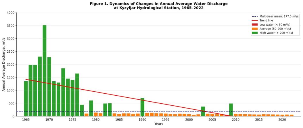
The analysis of hydrological observations at the Kiziljar gauging station for the period 1965–2022 revealed a significant long-term decreasing trend in the Amu Darya discharge in the delta [1]. Thus, the multi-year discharge is on average equal to Q0 = 177.5 m³/s; the coefficient of variation Cv = 1.08, the coefficient of skewness Cs = 1.79, which indicates a high variability of flow [6]. These values should be considered as approximate since, for the Kiziljar station, the error of the gauging method can be up to ±5 % (Section 2.1). However, the identified trend significantly exceeds this error level. The maximum monthly discharge was noted in 1969 and was equal to 3,530 m³/s, while in individual months in 2001, the discharge was as low as 2.1 m³/s. In the last 30–35 years, discharges of more than 1,000 m³/s have become significantly less common. Thus, the 3 % exceedance discharge is 714.1 m³/s (1980), the 50 % exceedance discharge is 116.9 m³/s (2000), and the 96 % exceedance discharge is 2.83 m³/s (2021).
2. Morphometric Parameters of the Reservoirs
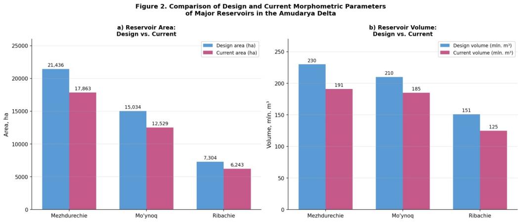
Field measurements and GIS-based morphometric modeling (see Section 2.3) allowed us to assess present-day morphometric parameters of the Mezhdurechenskoye reservoir (October 2022) and the Muynak and Ribachye reservoirs (November 2023) [7]. According to the field measurements, at the design level of 57.30 m a.s.l., the Mezhdurechenskoye reservoir’s total storage is 190.9 million m 3, while according to ArcGIS TIN modeling, it is 230.8 million m 3 . At present, its surface extends over 17,863 ha, which is 16.7 % less than the design size of 21,436 ha. The Muynak reservoir’s surface area is 12,529 ha, which is 16.7 % less than the design size of 15,034 ha. Its total storage is 184.9 million m 3, which is 12.8 % lower than the design value of 210 million m 3 . As for the Ribachye reservoir, its surface area is 6,243 ha, compared to the design size of 7,304 ha, and its total storage is 124.9 million m 3, compared to the design value of 151.4 million m 3 . Thus, with the combined measurement uncertainty of 3 – 5 % (see Section 2.3), the decrease in the surface area of all three reservoirs by 14 – 17 % and the total storage by 12 – 17 % is obvious.
Table 1.
Morphometric parameters of principal reservoirs in the Amudarya Delta. Area and volume values carry an estimated combined uncertainty of ±3–5% (see Section 2.3)
| Parameter | Mezhdurechenskoye | Muynak | Ribachye | Total / Average |
|---|---|---|---|---|
| Design area, ha | 21,436 | 15,034 | 7,304 | 43,774 |
| Current area, ha | 17,863 | 12,529 | 6,243 | 36,635 |
| Reduction, % | 16.7% | 16.7% | 14.5% | 16.3% |
| Design volume, million m³ | 230.0 | 210.0 | 151.4 | 591.4 |
| Current volume, million m³ | 191.0 | 184.9 | 125.0 | 500.9 |
| Maximum depth, m | 5–6 | 4.0–4.2 | 3.5–4.0 | — |
| Mean depth, m | 0.5–1.2 | 1.48 | 2.0 | — |
| Design channel capacity, m³/s | — | 44 (Glavmyaso) | 50 (Marinkin) | — |
| Current channel capacity, m³/s | — | 15 | 20 | — |
3. Water Balance and Mathematical Modelling
By using the water balance model described in Section 2.4, calculations were carried out for 2010, which is a high-water year, 2019, which is an average-water year, and 2001, which is a low-water year, with the Visual C#. net implementation of the algorithm for both design and current conditions.
Table 2.
Water balance of the near-Amudarya region for years of differing water availability. Evaporation and filtration losses are shown with the estimated ±10–15% relative uncertainty described in Section 2.6; discharge-derived terms carry the ±5% gauging uncertainty noted in Section 2.1
| Parameter | High-water (2010) | Average-water (2019) | Low-water (2001) | Unit |
|---|---|---|---|---|
Total inflow (Samanboy g/s) |
16,817.7 | 1,674.4 | 100.9 | million m³/year |
| Channel losses | 4,204.4 | 418.6 | 25.2 | million m³/year |
Total evaporation (all reservoirs) |
14.5 ± 1.5–2.2 | 11.4 ± 1.1–1.7 | 4.95 ± 0.5–0.7 | million m³/year |
| Filtration losses | 1.30 ± 0.13–0.20 | 1.14 ± 0.11–0.17 | 0.45 ± 0.05–0.07 | million m³/year |
| Discharge to Aral Sea | 12,214.9 | 852.4 | 0.0 | million m³/year |
| Water retained in reservoirs | 499.98 | 500.03 | 218.8 | million m³ |
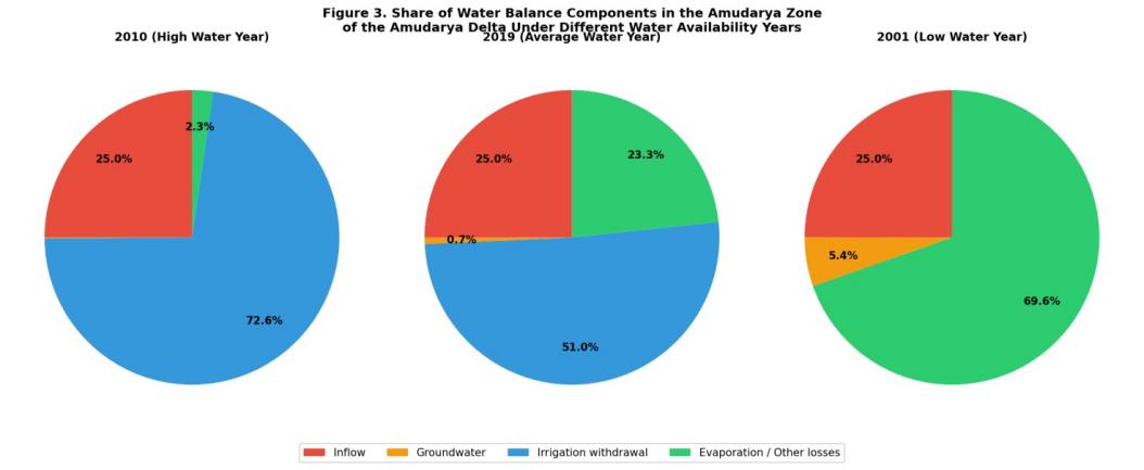
In the year of high discharge, 2010, the total inflow was 16817.7 million m³, of which 79.8 % was discharged through the channels into the former Aral Sea bed. In the year of average discharge, 2019, the inflow of 1674.4 million m³ allowed to keep the storage of all three reservoirs above 500 million m³. In the year of low discharge, 2001, the inflow was as low as 100.9 million m³, which is by an order of magnitude less than the combined storage of the three reservoirs (currently, 230 + 139 + 151 = 520 million m³). Reconstruction of the canal infrastructure (restoration of the discharge of the Glavmyaso Canal to 44 m³/s and the Marinkinuzyak Canal to 50 m³/s) would allow to fill the Mezhdurechenskoye Reservoir (230 million m³) to full capacity and partially refill the Muynak (139 million m³) and Ribachye (151 million m³) reservoir to their design volumes [8], given the ±10 – 15 % error margins of the evaporation / filtration terms (Section 2.6). This conclusion is not affected by the ±10 – 15 % error margins of the model’s input parameters.
3.1. Model verification
The design volumes used in the model as target values for the reservoirs (230.0 million m³ for Mezhdurechenskoye at NPU 57.30 m, 139.0 million m³ for Muynak at NPU 54.50 m, and 151.0 million m³ for Ribachye at NPU 54.00 m) are standard for the respective reservoirs and were verified against the current storage volumes found in the field / in ArcGIS in Section 2.3. A quantitative verification of the model (Nash-Sutcliffe efficiency, RMSE compared to an independent storage time series) was not carried out in this study but is recommended for future work when multi-annual reservoir storage time series become available.
3.2. Economic and institutional considerations
A full economic feasibility analysis of the proposed measures was beyond the scope of this hydrological / hydrobiological study, as it would require detailed engineering and surveying work that was not available to the authors. However, as shown in Table 2, the reconstruction of the canals would allow to fill the Mezhdurechenskoye Reservoir and partially refill the Muynak and Ribachye reservoirs to their design volumes even in the year of average discharge, thus ensuring the water supply for irrigation, fisheries, and reducing the need for costly alternative measures in other parts of the delta. The creation of a water management consortium and the development of water user associations as a mechanism for basin-level resource management [21] could be considered as an institutional solution to the problem. An economic assessment of the proposed solution, balancing the costs of the reconstruction with the benefits from the creation of the reservoirs, is recommended for future research.
3.3. Sensitivity to climate change
The decreasing trend in the mean annual discharge and the increasing trend in its variability observed in the 1965 – 2022 discharge series (Cv = 1.08) could be consistent with the climate change scenario for the region, which involves a temperature rise and a decrease in snow and glacial meltwater resources in the upper reaches of the Amudarya River. In such a scenario, the number of years with low discharge (similar to 2001, see Table 2) will increase, which will reduce the filling rates of the reservoirs to the levels indicated in Table 2 even after the proposed measures. A quantitative analysis of the impact of climate scenarios on the inflow to the reservoirs (using downscaled climate projections as input) was not carried out in this study but is recommended for future research. Given the relatively simple structure of the model used (Section 2.4), the easiest way to implement this analysis would be to use a lumped conceptual model (e. g., SWAT or MIKE SHE) that explicitly considers the impact of climate change on the catchment areas of the reservoirs. This approach would be more resource-intensive but would provide more insight into the sensitivity of the reservoirs to climate change; a combined analysis using the model described in this study and a distributed model is recommended for future research.
4. Hydrobiological Investigations (Zooplankton)
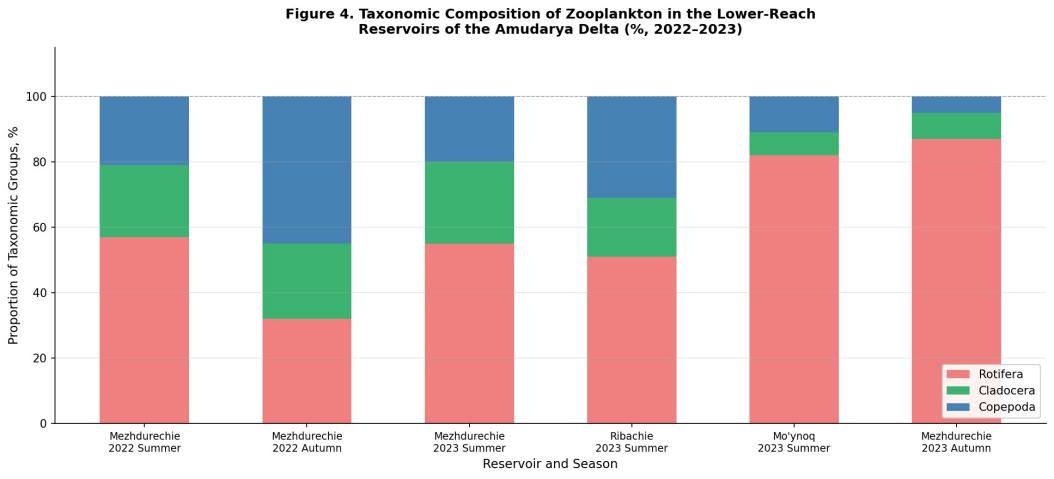
During the 2022 – 2023 field season, 32 zooplankton samples (23 quantitative and 9 qualitative) were taken in the lower reaches of the Amudarya River reservoirs, following the procedure described in Section 2.5. In total, 27 species of zooplankton were found, including 15 species of Rotifera (55.6 %), 6 species of Cladocera (22.2 %), and 6 species of Copepoda (22.2 %) [9].
Table 3.
Zooplankton species richness in lower Amudarya reservoirs (2022–2023), based on the sampling protocol described in Section 2.5
| Reservoir | Summer 2022 | Autumn 2022 | Summer 2023 | Autumn 2023 |
|---|---|---|---|---|
| Mezhdurechenskoye | 14 | 9 | 14 | 8 |
| Ribachye | — | — | 6 | — |
| Muynak | — | — | 11 | — |
| Total | 14 | 9 | 31 | 8 |
The largest number of zooplankton species (27 species in total) was found in the Mezhdureschenskoye reservoir. In the Ribachye and Muynak reservoirs, zooplankton were studied only in summer 2023, due to the limited water levels. The greatest number of zooplankton was found in August: 4,400 mg/m 3 in the Mezhdureschenskoye reservoir, 231 mg/m 3 in the Ribachye reservoir, and 124 mg/m 3 in the Muynak reservoir (mean values for stations; section 2.5). Of these, 96 % were copeods (Copepoda). In the lower reaches of the Amudarya reservoirs, seven species of zooplankton were detected for the first time: Hexarthra mira, Asplanchna sieboldi, Polyarthra vulgaris, Bdelloida gen. sp., and other species. However, Keratella tropica, Thermocyclops vermifer, and some other species recorded in the study by Ginatullina et al. (2006) were not found.
Conclusion
1. A systematic decline in Amudarya discharge at Kiziljar station was recorded over 1965–2022, with a mean flow of 177.5 m³/s and Cv = 1.08; the marked decrease in peak discharges over recent decades has substantially reduced water reaching the delta reservoirs.
2. Field measurements and ArcGIS-based TIN modelling (Section 2.3) confirmed that current morphometric parameters of all three reservoirs fall below design by 14–17 % in area and 12–17 % in volume — well outside the estimated ±3–5 % measurement uncertainty — reflecting significant sedimentation and hydrological degradation.
3. The water balance model, developed and verified against field/ArcGIS-derived storage values (Sections 2.4, 3.1), demonstrates that reconstructing the Glavmyaso and Marinkinuzyak canals would restore reservoirs to near-design storage capacity, though its economic justification requires a dedicated cost–benefit analysis (Section 3.2) beyond the scope of this study.
4. Hydrobiological surveys, using the sampling protocol described in Section 2.5, identified 27 zooplankton species across the reservoirs. Mezhdurechenskoye showed the greatest diversity and highest biomass (4,400 mg/m³), reflecting its more stable regime; productivity declines sharply in low-water years, indicating ecosystem vulnerability.
5. The observed increase in discharge variability over 1965–2022 suggests that climate-driven declines in Amudarya flow may reduce the long-term effectiveness of canal reconstruction alone, underscoring the need for climate-scenario modelling in future planning (Section 3.3).
6. The research findings have been implemented at the Priaralie Delta Directorate under the Ministry of Water Resources of the Republic of Karakalpakstan and at the Nukus branch of the International Fund for Saving the Aral Sea.
References